

DISCLAIMER : We the Osharians do NOT condone any radical activities, nor do we support anything illegal to the constitution of America. We do not agree with or support any form of terrorism or Satanic or Demonic practices, or racism. The views expressed here are only the opinions of The Osharian school of research based on ancient records and research. This public website is to be considered for entertainment purposes only.
For more information please refer to the " Directory of the Atlanteans " which is updated every week.
https://osharresearch.blogspot.com/2023/01/osharian-directory-of-enoch-4.html?m=0
:Meso American connection to Atlas:
It would seem that Teotihuacán had brought their knowledge of Atlas and their ancestry and collaborated with the indigenous peoples of the Zapotec.
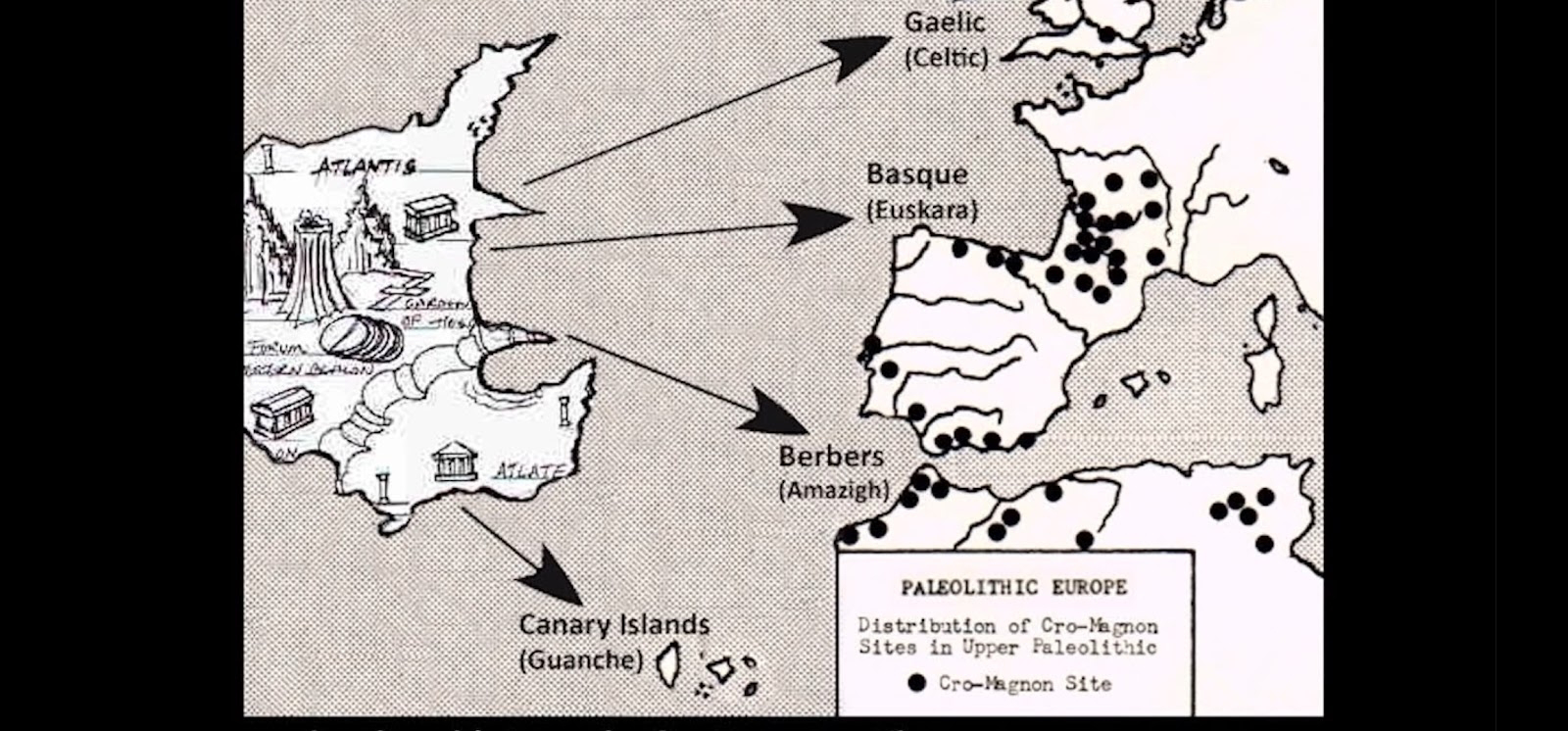
Cro magnon migration from the Atlantic region into the Americas began 35,000 to 30,000 BC.
Publicly known legend of the migration from Aztlan:
The Aztecs, also known as the Mexica, migrated south from Aztlan to what would become modern-day Mexico. The Aztecs were the last of seven Nahuatl-speaking tribes to make the journey, which is how they got their name.
Creation of the world:
The Aztecs believed the world was created and destroyed four times before, in a cycle called the "Legend of the Fifth Sun". Each cycle was ruled by a different god and was marked by a new sun. The gods finally succeeded on the fifth attempt.
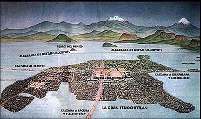
Founding of Tenochtitlan. This directly correlates to the Atlantean myths of four break ups of land in the Atlantic.
The Aztecs believed they should found their city on an island in Lake Texcoco after seeing a vision of an eagle holding a rattlesnake on a nopal cactus. They built Tenochtitlan on an artificial island in the center of what is now Mexico City. The vision is depicted on the Coat of Arms of Mexico today.

Teotihuacan, Tenochtitlan, Tlamachathl:
In the Nahuatl language Tlamachathl "New water home".
The name Teotihuacan, when translated from the Aztec Nahuatl language means "The place where men become gods."
This would have been the original name for Atlantis in the Nahuatl language.
" Ixtlamatinih tocolhuan chicome co ". In English: " Place of the seven ancestors of knowledge ".
ixtlamatinih ( sage or knowledgeable ones )
Chicome ( the number 7 )
tocōlhuān ( ancestors )

Tocōlhuān ( ancestors )
Nahuatl translates into English As ( The intelligent audible water that flows in all four directions
. )
The word or term " Atl " is first found in the Aztec Codex Magliabechiano. Atl, meaning water by itself and also when related or used in some other Aztec words, specifically in names. But the ' Atl ' does not always mean water in all contexts.
The belief was that Teotihuacan was where the great gods held council after the destruction of the island known to them as Aztlatlan. Atlan being the people of Atlas. Aztec belief was that their origins home in this island of plenty, was eastwards across the Atlantic.

Further intrigue comes from the word Atl. In the Nahuatl language it means water. In the Berber Amazigh language ' Atlan ' means in the middle of water. The Berber language of the Berbers of Morocco call their language Atlasic, meaning language of Atlas.
Or as the Greeks translated it, " The circle in the midst of water." " An " meaning land and " tis " meaning of a certain something that is important or someone . So Atl-an-tis water land of something or someone important.

The word or term " Atl " is first found in the Aztec Codex Magliabechiano. Atl, meaning water by it's self and also when related or used in any Aztec word. Athl with a h means ' home of the water '.

The Nahuatl language being the closest related language to the possible Atlantean language besides the Amazigh Berber language.
In the Nahuatl Aztec language:
Nahuatl: Nahu= going in all 4 directions.
Atl= water
Nahuatl= water going in all 4 directions.
Tlamachathl: "New water home".
Atlas: Atl = water
As = water, but also means waters as in plural.
So Atlas could mean water, water, water.
As a trinity it might refer to water in it's three primary states.
1) gas ( Fire & water )
2) liquid (water & water )
3) solid ( Earth & water )
Also refers to three locations:
1) Atlantic
2) Mesoamerica
3) Northwest Africa
In the central island believed to be located in what is now called the Azores islands in the North Mid-Atlantic region ( Atlas Massif ).
This island had three great city-states. Here is the Etymology of the names:
1) Ari Nepantla ( Ari= The people of Atlas ) and ( Nepantla= "in the middle or middle of it" ).
2) Paos, P, Aos. A= towards os= the P= place as in a location.
So Paos might translate in English as " Towards the place ".
3) Aden, Ad= water when connected to another word. Example Adatl= " In the water. and En= A location inside of water.
So possible English translation would be " The water inside the waters".
*Atlas ( Atl= water and As= waters, as in plural ).
* Atl-as then would translate to " Water of the waters". " The water in side of the waters ".
Could this be hinting about the structural design of the city-states? Water within waters. Three circles of water?
One possible candidate to have been an Atlantean city-state is the eye of the Sahara, Richat structure. In the recorded records of the Amazigh Berber ( Atlasic language as Akassa Ari ).
We find the remains of only the bedrock primarily. But the chemical composition that was found there at the site is quite interesting. We found alkaline deposits along with quartz crystal in the rings. In theory the waters had strong currents that went around in circles. The high levels of alkaline and quartz would have created a battery type effect.
Also we have a term "holy of the holies". I wonder then if water was holy to Atlanteans and if so could "water of the waters" have a similar meaning.
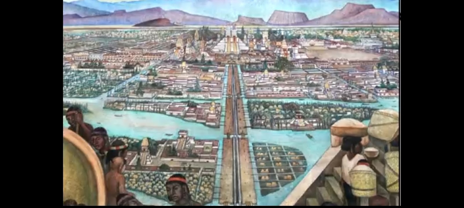
Housing plan development of Teotihuacan:

The remaining pyramid of the sun shows evidence that it was used as a power station. Also these pyramids were built on top of each other multiple times.

There are many strange features. Such as mica being found which is a non conductive heat resistant material use on rockets ships for re-entry. Also a large amount of refined liquid mercury was found. Liquid Mercury being used in frequency phymatic motors. Then they found a volcanic tube vent that might have been active when the site was first built. We find other sites like Gong Padang pyramid using active volcanic vents in these pyramids. This would indicate that some of these pyramid site where using volcanic energy some how.

Atzland ( Teotihuacan ): Aztlan was one of 3 primary Atlantean capital city-states. It was built in lake Tezcuco that had seven islands that had natural volcanic springs. Before that, there was only one island in the middle. Their original city-state was destroyed from volcanic earthquakes thousands of years before the return of the Aztecs. This happened many times over and this site was rebuilt multiple times.
There were several migrations at different times.

The seven Nahua tribes are said to have lived in Chicomoztoc in the lake basin of Tehuacan valley.
The basin consisted of five major connecting lakes.
1. Zumpango
2. Xaltocan
3. Texcoco
4. Xochimilco
5. Chalco
" The place of the seven caves ".
Nahua groups from the seven caves were as follows:
(1) Xochimilca
(2) Tlahuica
(3) Acolhua
(4) Tlaxcalteca
(5) Tepameca
(6) Chalca
(7) Mexica

A discovery was made while studying the origins of agriculture in the Tehuacan Valley in Mexico. The researchers needed to establish a date for the earliest human occupation in the Coxcatlan Cave, suspected location of " The place of the seven caves.
So they obtained radiocarbon dates for several cooked rabbit and deer bones that were collected from the cave in the 1960s as part of the Tehuacan Archaeological-Botanical Project.
The dates range for the bone samples from the base of the caves ranged from at 33,448 BP at the back of the caves to the front of the cave at around 28,279 BP. Note that the animals had originally been cooked then broken to extract the bone marrow.

Later after the breaking up of the island into 7 smaller islands the peoples used floating islands around the original island to grow crops. This allowed them to grow crops all year around. This was obviously an inherited knowledge pass downed from their mother civilization. This technique is called ' Chinampas '. The lake was connected by way of a canal that ran from the lakes to the gulf of Mexico and out into the Atlantic ocean. The emerald reactor was at the center of this city state until around 28,000 B.C. when meteor impacks from the Taurids first struck.


New evidence indicates the possibility that chinampas might have been used in concentric circles or rings. Although later drawings may seem to show square like formations; we now know this to not be the truth of how they built.
The multiple migrations at different times indicates that the Aztecs might have been improperly dated in the records of civilizations of the Americas in linear time. The Aztec may actually predate the Toltecs, Inca and Mayans.
They were using the caves and had colonies in the Americas long before the 28,000 BC second break up in the Mid-Atlantic.
The pyramid of the Sun aligns with Orion's belt. The when is still under debate. And the moon pyramid aligns with the Pleiades.
Iltarian legends claim that their ancestors came from both the Pleiades ( 7 sisters ) and Orion's belt.

Aztlán (also spelled Aztlan , Aztalan, or Nahuatl Aztlatlan ), is the name of the mythical homeland of the Aztecs, the ancient Mesoamerican civilization also known as the Mexica. According to their origin myth, the Mexica left Aztlan ( Atlantic main island in the Azores ) at the behest of their god/ruler in that time period ' Huitzilopchtli ', to restore and rebuild their old city-state in the Valley of Mexico.
Huitzilopchtli might have been a direct descendant of Aronus and Atarti.
Aztlan was a luxurious and delightful place located on a large lake, where everyone was lived happily among abundant resources. There was a steep hill called Colhuacan in the middle of the lake, and in the hill were caves and caverns known collectively as Chicomoztoc, where the ancestors of the Aztec lived.
The tradition of Aztlan has a long history full of different inhabitants over the ages. Quetzalcoatl is shown upholding the heavens in a Aztec painting preserved in the imperial library of Vienna.
The T shaped pillars are a depiction of humans and is derived from the T in AT or Atlan. This culture was global before settling down in Meso- America.

There is a legend of an Atlantean prince that was exciled by those of the main islands. Axolotl (Xolotl brother of Quetzalcoatl) became king of the Aztlan for a time. But it was decided that Axolotl was to be brought back to the main island to be put on trail for war crimes. The legend says he went deep in the waters of the great lake of Aztlan and disguised himself as a small amphibian later named Axolotl after the missing king that was never to be found again. The Axolotl do originate from Lake Texaco ( Leguma De Tezcuco).


Aztec ( Nahuatl ): Quetzalcoatl's two forms are the Feathered Serpent and Ehecatl which is the god of wind.
He was also the patron god of the Aztec priesthood. Among the Aztecs he was associated to the wind, merchants, knowledge, and learning.
Quetzal-co-atl break down of the meaning of name in Nahuatl language:
Quetzal: tail feather
Co: place
Atl: water
Coatl: serpent
This in English would translate to:
" Water place of the serpent's tail feather ".
We know that serpents don't have tail feathers. So what is the feather of the serpent? Might it be referring to the Fallening angels myth that is not directly said in the Bible. In this myth angels becomes fallen angels. They descend down to Earth but is of heaven and Earth. The feathers can represent the two wings of the angels. One wing is said to have returned to the above. So without the knowledge of the above, they were unable to go back from where they had come from. In this analogy there is a head feather and a tail feather. Which symbolize the wings and the path or process of coming from the highest ( head ) to the lowest ( tail ), is the knowledge of Good ( above ) and evil ( below ). But can also represent ascension and decension of the different dimensions. The head being the 12th and above dimensions and the tail being the 3rd and below dimensions.
So the tail feather may be the sacred knowledge of the Atlanteans. The head feather would be the sacred knowledge of the Azerians that was passed down from head to tail.

____________________________________________
Follow up site:
:Another possible Atlas related site:

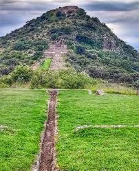
Pyramid of Xochicalo is located 60 miles south east of modern day Mexico City.
" The pyramid was a monumental structure erected to commemorate the submergence and destruction of the great land of Plato's Atlantis. Together with its population of 64 million human beings, about 11,500 years ago.
Atlas Obscura: A list of ancient sites: One of these is Pyramid of Xochicalo.
The glyphs there illustrate a great deluge in the Atlantic and a migration into Mesoamerica.
How the ruins look today.

"Lord of Time" glyphs of Pirámide Quetzacoatl. The Pyramid of the Plumed Serpent is unusual for a variety of reasons.
The Maya figures on the talud level may represent priests of the Quetzalcoatl cult originally established by the leader who had adopted that name while he ruled Xochicalco.
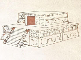
How the pyramid once appeared. An artist's rendering shows a covered structure on top of the base. The roof has long-since disappeared, exposing the pyramid's hollow interior. As is often the case with Mesoamerican ceremonial structures, archaeologists found an earlier structure underneath the Plumed Serpent pyramid.
View of the north side of the pyramid. Each of the taluds on the sides and back have a similar design: two long writhing snakes, with their heads at the corners turned to face each other. The tails meet in the middle of the talud. The two snakes on the front of the pyramid are separated by the staircase. The design of the snakes shows a strong Teotihuacán influence.

The Plumed Serpent's head, from the northwest corner. The head and neck are fringed with feathers, clearly identifying the serpent as a manifestation of Quetzalcoatl. The mouth gapes open, showing upper and lower fangs curving back. Protruding from the mouth is a long forked tongue. The fork in the tongue has been interpreted as a symbol of the New Fire ceremony, which took place at the end of each 52-year cycle in the sacred calendar. This was a ceremony of great significance because the change-over from one cycle to the next was a moment of cosmic death and rebirth, a time of great danger. On the day of the New Fire ceremony, all fires were extinguished and could only be re-lit when the ritual was complete. Quetzalcoatl was himself a symbol of death and re-birth, which probably is the connection with the New Fire symbol.

Maya-style figures sit between the undulations of the snake's body. There are a series of similar--but not identical--figures on all four sides. For reasons I will explain later, these individuals are sometimes called the "Lords of Time." The seated postures and the figures' profiles show a strong Maya influence. The attire is similar to that of the Lord of the Serpents, except that the head dress is more elaborate. However, these Maya figures are much more artfully created, indicating that the Lord of the Serpents may not have been crafted by a Maya artisan. To the right of the figure is a symbol which may indicate either speech or a place of origin. The combination of Teotihuacán-style Plumed Serpents with Maya-style figures shows that the great empire's refugees apparently shared power with the Olmeca-Xicalanca, a Maya group from the Yucatan's Gulf Coast. The Olmeca-Xicalanca moved into the territories of the Teotihuacán Empire as it began to collapse. They founded Xochicalco's trade rival, Cacaxtla, at about the same time Xochicalco was built.

Other depiction of the Time lords:


This chronicles the survivors starting over and teaching of the indigenous people.

Large monolithic single piece sculpture of the wind god Ehecatl. Being another form of Quetzalcoatl.
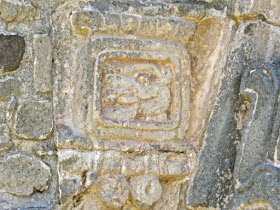
These symbols were placed inside other curves of the snakes' bodies. At the bottom, you can see a single bar with four dots below it. The dots each represent the number 1 while the bar represents 5. Together, they form the number 9 in the Zapotec numeric system. The inclusion of Zapotec numbers shows the third major influence on Xochicalco's architecture and culture. The complex symbol above the number means "Eye of the Reptile". Above it, the symbol for New Fire occurs again. All together, this forms a written version of Quetzalcoatl's name. However, it can also be read as a date, 743 AD, when an eclipse occurred.

A series of stylized conches for the cornice of the tablero. The connection between conches and Quetzalcoatl can be found in his myth. The Plumed Serpent volunteered to populate the newly created world with human beings, but needed materials. To obtain them, he had to enter the underworld and undergo many trials in order to recover bones from perviously destroyed worlds. Mictlantecuhtli, the God of Death, refused to give up the bones unless Quetzalcoatl traveled around the underworld four times blowing a trumpet made from a conch shell. However, this was a trick because the conch had no holes for blowing. Quetzalcoatl overcame this obstacle by persuading underground worms to drill the holes. He filled the conch with a swarm of bees to amplify the sound. When Mictlantecuhtli heard the Plumed Serpent blasting on the trumpet, he was forced to give up the bones. A final trap set by the Death God caused Quetzalcoatl to fall and break the bones into many pieces of various sizes and shapes. This is the reason that people appear to be different from one another.

Interior of the pyramid. From this view, it appears that there may have been at least two floors, the upper one supported by the pillars. There is no staircase or other obvious route down into the bottom level. In the center-left, behind a pair of pillars, is a low square platform which was probably an altar.

Relief carving from the right side of the pyramid's upper level entrance. Originally there were a number of similar--but not identical--carvings on the back, sides, and front walls of the second level. This is one of the few that is nearly intact. The figure in the center is seated in a cross-legged position. The face is worn away, but other elements of the carving are still clear and sharp. A cluster of arrows is strapped to his back, suggesting a military commander, or possibly a ruler. An elaborate necklace is draped around his neck and shoulders and he wears a bracelet on his right hand. Both of these indicate a high-ranking individual. The outstretched hand grasps a staff of power. To the left of the figure is a date glyph with the Zapotec number 8 at the bottom. On the right, at the top, is a fruit-bearing tree or possibly a stylized maiz plant with the ripe cobs. Below it is a rather abstract image of a crocodile sitting upright with the tail curled. While the seated human figure in each three-panel carving is similar to the others on the second level walls, the images, symbols and numbers on either side of the figures differ from one three-panel group to another.


upper-tier figures are rulers of other regional powers, such as Cacaxtla and La Quemada, who may have come together at Xochicalco to participate in the observation of an eclipse in 743 AD. The symbols and animals accompanying each figure might indicate their kingdom and the dates of their accession to their thrones or of their alliances with Xochicalco. The Maya figures entwined by the snakes on the lower level would then be the "Lords of Time", i.e. Maya priest-astronomers who had arrived hoping to use the occasion of the 743 AD eclipse to re-calibrate their calendars. The Maya mastery of astronomy, mathematics, and calendric calculations was far in advance of the rest of Mesoamerican societies.
A depiction of their place of origin being destroyed first by fire then by water.

So in conclusion, We now conceive of a direct record of transition from an Atlantic Atlas region based culture to American base culture. Perhaps there is much more to investigate down this rabbit hole.
